
Integrating the Electronic Desktop into the Natural Sciences
Curriculum Development Project at California State University, Los Angeles
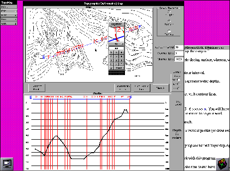
TopoMap is an application written for use in general education introductory courses in earth sciences such as physical geology and oceanography. Students interact with topographic maps (or bathymetric charts) to construct profiles which give a cross-sectional view of the landscape. The application helps students understand contour lines, the contour interval, vertical and horizontal scales. It also helps them to determine the relationship between these map and chart properties and topographic or submarine features. A digitizer object can be used to zoom-in on a particular feature enter the elevation. A companion electronic lab manual has hot links into TopoMap and worksheet documents which help to structure their lesson. This application was written by Dr. Gary Novak. The digitizer object was written by Dr. Robert Desharnais.
Click to download full resolution image (62.1 KB.)
The Electronic Desktop Project is about improving the way science is taught and learned by bringing the power of advanced workstation technology to introductory science students in both major and general education classes. This involves changing the way in which instruction is delivered using multi-media electronic mail, custom written visualization applications, powerful commercial software packages, and easy-to-use graphical applications that bring the resources of the Internet into the electronic classroom. This project has been funded by grants USE 9153162, DUE 9156142 and DUE 9455428 from the National Science Foundation. For more information contact Dr. Robert Desharnais (biology), (213) 343-2056, rdeshar@calstatela.edu, or Dr. Gary Novak (geology), (213) 343-2406, gnovak@calstatela.edu, California State University, Los Angeles, California, 90032.
 Return to the Application Catalog
 Topomap